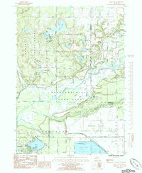
1985 Map of Wolf Lake
USGS Topo · Published 1985About this map
The Little Muskegon River and Maple River converge in this mid-1980s survey, creating a landscape defined by wetlands and conservation. A significant portion of the terrain is dedicated to the Muskegon State Game Area and the eastern edge of the Manistee National Forest, reflecting the region's focus on resource management and outdoor recreation. The settlement of Wolf Lake sits at the southwestern corner, anchored by Wolf Lake County Park and the John F Kennedy Memorial Park.
Find a feature on this map
48 named features on this map. Tap any name to fly to it.
Don’t see what you’re looking for? This feature index may not catch every label — zoom into the map to look around manually.
Map Details
Editions of this 1985 Wolf Lake Map
This is the sole edition of this map. No revisions or reprints were ever made.
Other maps of this area

1930 · Muskegon
USGS Topo · 1:62,500

1936 · Muskegon
USGS Topo · 1:62,500

1945 · Ravenna
USGS Topo · 1:62,500

1954 · Milwaukee
USGS Topo · 1:250,000

1954 · Midland
USGS Topo · 1:250,000

1958 · Midland
USGS Topo · 1:250,000

1958 · Milwaukee
USGS Topo · 1:250,000

1958 · Twin Lake
USGS Topo · 1:62,500

1958 · Fremont
USGS Topo · 1:62,500

1959 · Midland
USGS Topo · 1:250,000
Featured Places
- Wolf Lake, MI
- Egelston Township, MI
- Cedar Creek Township, MI
- Moorland Township, MI
- Bridgeton Township, MI