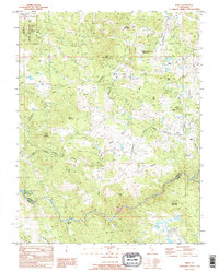
1995 Map of Wolf
USGS Topo · Published 1995About this map
Wolf and Garden Bar sit at the center of this mid-1990s survey, documenting a landscape where historic mining and modern water management intersect. The boundary between Nevada and Placer counties follows the winding path of the Bear River, while the southern reaches show the intricate infrastructure of the Camp Far West Reservoir Spillway and the Camp Far West Canal. This era of the landscape is defined by its transition toward conservation and large-scale utility, evidenced by the expansive Spenceville Wildlife and Recreation Area and the Combie Aqueduct.
Find a feature on this map
31 named features on this map. Tap any name to fly to it.
Don’t see what you’re looking for? This feature index may not catch every label — zoom into the map to look around manually.
Map Details
Editions of this 1995 Wolf Map
This is the sole edition of this map. No revisions or reprints were ever made.
Other maps of this area

1888 · Smartsville
USGS Topo · 1:125,000

1891 · Sacramento
USGS Topo · 1:125,000

1891 · Smartsville
USGS Topo · 1:125,000

1892 · Sacramento
USGS Topo · 1:125,000

1892 · Smartsville
USGS Topo · 1:125,000

1893 · Sacramento
USGS Topo · 1:125,000

1894 · Smartsville
USGS Topo · 1:125,000

1895 · Smartsville
USGS Topo · 1:125,000

1910 · Lincoln
USGS Topo · 1:31,680

1915 · Spenceville
USGS Topo · 1:31,680