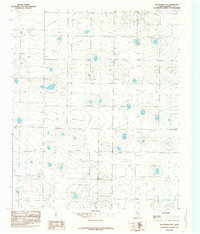
1985 Map of Wolfforth NW
USGS Topo · Published 1985About this map
Deep groundwater resources and petroleum extraction define this section of the High Plains in Hockley County. The landscape is dominated by a systematic grid of water Wells, supporting the intensive agricultural needs of the region during the mid-1980s. Industrial activity is concentrated in the southern portion of the quadrangle, where an expansive Oil Field indicates the importance of the Permian Basin's energy production. A localized Sub Station provides the necessary electrical infrastructure to support these widespread pumping operations. The terrain is characterized by numerous small depressions and basins, a distinctive geological pattern of the Llano Estacado, which influences the distribution of the area's essential water and mineral resources.
Find a feature on this map
4 named features on this map. Tap any name to fly to it.
Don’t see what you’re looking for? This feature index may not catch every label — zoom into the map to look around manually.
Map Details
Editions of this 1985 Wolfforth NW Map
This is the sole edition of this map. No revisions or reprints were ever made.
Other maps of this area

1954 · Brownfield
USGS Topo · 1:250,000

1957 · Anton
USGS Topo · 1:62,500

1957 · Wolfforth
USGS Topo · 1:62,500

1958 · Brownfield
USGS Topo · 1:250,000

1962 · Brownfield
USGS Topo · 1:250,000

1964 · Lums Chapel
USGS Topo · 1:24,000

1964 · Whitharral
USGS Topo · 1:24,000

1965 · Levelland East
USGS Topo · 1:24,000
1976 · Anton SW
USGS Topo · 1:24,000
1976 · Wolfforth NW
USGS Topo · 1:24,000