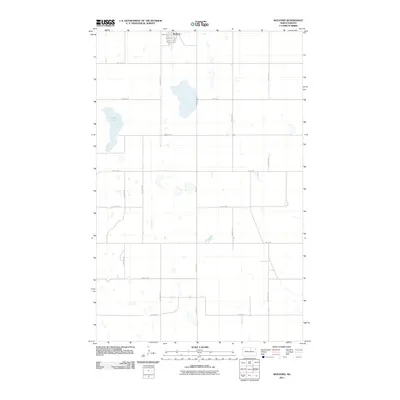
2011 Map of Wolford
USGS Topo · Published 2011About this map
Wolford sits at the northern edge of this North Dakota prairie landscape, organized around a traditional grid of streets including Main St and Peter St. The surrounding countryside is defined by the section-line road network and a scattering of natural wetlands and prairie potholes typical of the region. Guss Lake is the most prominent water body, located west of the main settlement. The transit of the area is facilitated by established routes like Knox Rd and 44th Ave Ne, which cut through the agricultural blocks. This 2011 survey illustrates the persistent rural character of the northern plains, where small town centers remain the primary focal points of the landscape amid wide expanses of territory defined by names like 74th St Ne and 70th St Ne.
Find a feature on this map
22 named features on this map. Tap any name to fly to it.
Don’t see what you’re looking for? This feature index may not catch every label — zoom into the map to look around manually.
Map Details
Editions of this 2011 Wolford Map
This is the sole edition of this map. No revisions or reprints were ever made.
Other maps of this area

1953 · Devils Lake
USGS Topo · 1:250,000

1956 · Devils Lake
USGS Topo · 1:250,000

1971 · Wolford
USGS Topo · 1:24,000

1971 · Island Lake
USGS Topo · 1:24,000

1971 · Knox
USGS Topo · 1:24,000

1971 · Rugby NE
USGS Topo · 1:24,000

1971 · Hurricane Lake West
USGS Topo · 1:24,000

1971 · York
USGS Topo · 1:24,000

1971 · Mylo SE
USGS Topo · 1:24,000
1971 · Pleasant Lake
USGS Topo · 1:24,000