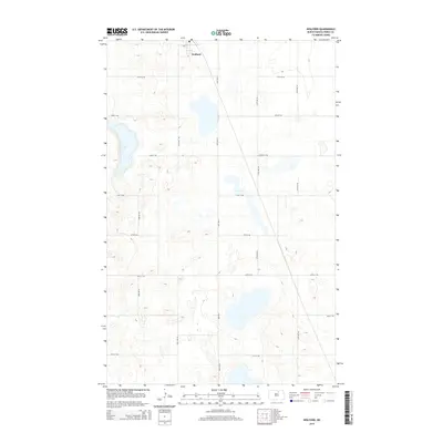
2014 Map of Wolford
USGS Topo · Published 2014About this map
Wolford sits at the northern edge of this Pierce County landscape, centered on the intersection of Main St and a grid of rural section roads. This part of North Dakota is defined by a prairie pothole terrain, where dozens of unnamed wetlands and small basins dot the agricultural sections alongside Guss Lake. The infrastructure is dominated by a systematic grid, including north-south corridors like Knox Rd and 45th Ave N, which facilitate movement through the farming blocks. This 2014 survey documents the enduring spatial layout of the rural township, illustrating how the natural topography of the glacial till plain influences the placement of these vital local transport routes.
Find a feature on this map
17 named features on this map. Tap any name to fly to it.
Don’t see what you’re looking for? This feature index may not catch every label — zoom into the map to look around manually.
Map Details
Editions of this 2014 Wolford Map
This is the sole edition of this map. No revisions or reprints were ever made.
Other maps of this area

1953 · Devils Lake
USGS Topo · 1:250,000

1956 · Devils Lake
USGS Topo · 1:250,000

1971 · Wolford
USGS Topo · 1:24,000

1971 · Island Lake
USGS Topo · 1:24,000

1971 · Knox
USGS Topo · 1:24,000

1971 · Rugby NE
USGS Topo · 1:24,000

1971 · Hurricane Lake West
USGS Topo · 1:24,000

1971 · York
USGS Topo · 1:24,000

1971 · Mylo SE
USGS Topo · 1:24,000
1971 · Pleasant Lake
USGS Topo · 1:24,000