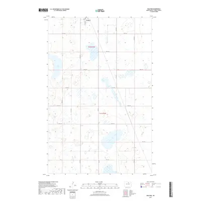
2017 Map of Wolford
USGS Topo · Published 2017About this map
Wolford sits at the northern edge of this North Dakota landscape, where the intersection of Main St and 3rd Ave anchors a small settlement amidst a dense network of glacial prairie potholes. The terrain is defined by an intricate pattern of wetlands and small water bodies, including Guss Lake, which dominates the western sections of t158n r70w. This 2017 survey reveals a grid of rural section roads like Knox Rd and 74th St NE that divide the land into large agricultural tracts. The high density of unnamed wetlands surrounding the few named features illustrates the typical drainage patterns of the northern plains, where natural depressions collect water across the township boundaries of t157n r70w.
Find a feature on this map
20 named features on this map. Tap any name to fly to it.
Don’t see what you’re looking for? This feature index may not catch every label — zoom into the map to look around manually.
Map Details
Editions of this 2017 Wolford Map
This is the sole edition of this map. No revisions or reprints were ever made.
Other maps of this area

1953 · Devils Lake
USGS Topo · 1:250,000

1956 · Devils Lake
USGS Topo · 1:250,000

1971 · Wolford
USGS Topo · 1:24,000

1971 · Island Lake
USGS Topo · 1:24,000

1971 · Knox
USGS Topo · 1:24,000

1971 · Rugby NE
USGS Topo · 1:24,000

1971 · Hurricane Lake West
USGS Topo · 1:24,000

1971 · York
USGS Topo · 1:24,000

1971 · Mylo SE
USGS Topo · 1:24,000
1971 · Pleasant Lake
USGS Topo · 1:24,000