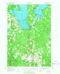
1957 Map of Wolverine
USGS Topo · Published 1966About this map
Burt Lake and Mullett Lake dominate this mid-century landscape, connected by the winding Indian River and the corridor of the New York Central railroad. The map documents a transition from industrial and wilderness use toward a recreation-based economy, evidenced by a dense ring of waterfront developments like Wauban Beach, Miami Beach, and Giauque Beach. These contrast with the vast acreage of the Hardwood State Forest and Pigeon River State Forest, which preserve the interior woodland character of the region.
Find a feature on this map
93 named features on this map. Tap any name to fly to it.
Don’t see what you’re looking for? This feature index may not catch every label — zoom into the map to look around manually.
Map Details
Editions of this 1957 Wolverine Map
3 editions found
Other maps of this area

1954 · Gaylord
USGS Topo · 1:62,500

1954 · Hetherton
USGS Topo · 1:62,500

1955 · Cheboygan
USGS Topo · 1:250,000

1957 · Tower
USGS Topo · 1:62,500

1957 · Wolverine
USGS Topo · 1:62,500

1957 · Cheboygan
USGS Topo · 1:62,500

1957 · Mullett Lake
USGS Topo · 1:62,500

1958 · Cheboygan
USGS Topo · 1:250,000

1958 · Pellston
USGS Topo · 1:62,500

1958 · Petoskey
USGS Topo · 1:62,500