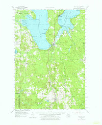
1957 Map of Wolverine
USGS Topo · Published 1976About this map
Burt Lake and Mullett Lake dominate this northern Michigan landscape, connected by the winding Indian River. In the mid-1950s, the region was a mix of recreational shorelines and dense woodlands, with numerous summer camps and beaches such as Wauban Beach, Giauque Beach, and Bowersocks Camp dotting the waterfronts. The New York Central railroad corridor serves as a primary north-south artery, passing through settlements like Topinabee and Wolverine. To the south, the terrain becomes more industrial and rustic, marked by the Hardwood State Forest and several Gravel Pits. Local history is preserved in the location of the Ohioville Sch and School No 1, alongside the Koehler Cem and Silver Lake Cem. The presence of the Wolverine Lookout Tower and Campbell Landing Field reflects the area's ongoing management and rural utility during this era.
Find a feature on this map
86 named features on this map. Tap any name to fly to it.
Don’t see what you’re looking for? This feature index may not catch every label — zoom into the map to look around manually.
Map Details
Editions of this 1957 Wolverine Map
3 editions found
Other maps of this area

1954 · Gaylord
USGS Topo · 1:62,500

1954 · Hetherton
USGS Topo · 1:62,500

1955 · Cheboygan
USGS Topo · 1:250,000

1957 · Tower
USGS Topo · 1:62,500

1957 · Wolverine
USGS Topo · 1:62,500

1957 · Cheboygan
USGS Topo · 1:62,500

1957 · Mullett Lake
USGS Topo · 1:62,500

1958 · Cheboygan
USGS Topo · 1:250,000

1958 · Pellston
USGS Topo · 1:62,500

1958 · Petoskey
USGS Topo · 1:62,500