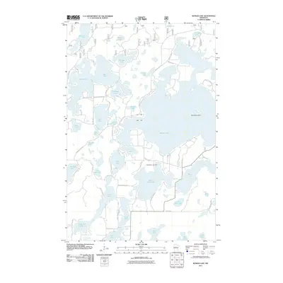
2011 Map of Woman Lake
USGS Topo · Published 2011About this map
Woman Lake dominates this northern landscape, its intricate shoreline and northern bays forming the center of a dense lacustrine network in Cass County. The map details the hydrology connecting these waters, including the Boy River and the regulated flow at Blackwater Lake Dam. To the west, a cluster of uniquely named bodies such as Child Lake, Man Lake, and Baby Lake suggest a long-standing local nomenclature for the interconnected basins. The presence of Horseshoe Island and various smaller points illustrates the complex glacial geography of the region. Road networks like County Hwy 11 and numerous township ways such as Woodrow Twp Hwy 6 provide access to the various lakefronts, showing a transition toward recreational and residential development along the shorelines of Black Water Lake and Mule Lake.
Find a feature on this map
60 named features on this map. Tap any name to fly to it.
Don’t see what you’re looking for? This feature index may not catch every label — zoom into the map to look around manually.
Map Details
Editions of this 2011 Woman Lake Map
This is the sole edition of this map. No revisions or reprints were ever made.
Other maps of this area

1953 · Brainerd
USGS Topo · 1:250,000

1954 · Bemidji
USGS Topo · 1:250,000

1957 · Brainerd
USGS Topo · 1:250,000

1957 · Bemidji
USGS Topo · 1:250,000

1958 · Bemidji
USGS Topo · 1:250,000

1958 · Brainerd
USGS Topo · 1:250,000

1965 · Brainerd
USGS Topo · 1:250,000
1970 · Mildred
USGS Topo · 1:24,000

1970 · Webb Lake
USGS Topo · 1:24,000

1970 · Woman Lake
USGS Topo · 1:24,000