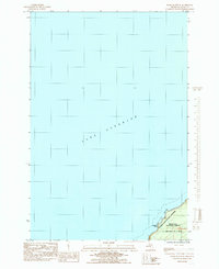
1984 Map of Wood Island SE
USGS Topo · Published 1985About this map
Lake Superior dominates this mid-1980s provisional study, meeting the jagged sandstone shoreline of the Pictured Rocks National Lakeshore. The map documents a sparsely settled but ecologically significant stretch of Alger County, where the cliffs of Pictured Rocks rise above the water near Bridalveil Falls. Inland, the terrain is defined by the dense acreage of the Hiawatha National Forest, bordering the northern limits of Munising. Because this is a provisional edition based on 1978 aerial photography and 1981 field checks, it captures the primitive road network and forest boundaries as they existed before modern development or major navigational changes. The map's primary focus is the intersection of these protected federal lands and the vast expanse of the Great Lakes coastline.
Find a feature on this map
7 named features on this map. Tap any name to fly to it.
Don’t see what you’re looking for? This feature index may not catch every label — zoom into the map to look around manually.
Map Details
Editions of this 1984 Wood Island SE Map
This is the sole edition of this map. No revisions or reprints were ever made.
Other maps of this area

1958 · Munising
USGS Topo · 1:62,500

1958 · Wood Island
USGS Topo · 1:62,500

1958 · Shingleton
USGS Topo · 1:62,500

1958 · Grand Portal Point
USGS Topo · 1:62,500

1958 · Marquette
USGS Topo · 1:250,000

1960 · Marquette
USGS Topo · 1:250,000

1961 · Marquette
USGS Topo · 1:250,000

1968 · Marquette
USGS Topo · 1:250,000

1983 · Munising
USGS Topo · 1:100,000
1983 · Grand Portal Point
USGS Topo · 1:24,000