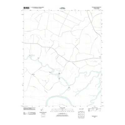
2010 Map of Woodard
USGS Topo · Published 2010About this map
The Sans Souci Ferry remains a defining transit point across the winding Cashie River, illustrating the enduring reliance on water-based travel in this riverine corner of Bertie County. The landscape is characterized by its intricate drainage networks, where the Roanoke River and Middle River converge near tidal creeks like Broad Creek and Swamp Creek. Small riverfront settlements and historical access points such as Jacocks Landing, Smithwick Landing, and Cooper Landing dot the riverbanks, marking long-standing sites of commerce and community in the coastal plain.
Find a feature on this map
33 named features on this map. Tap any name to fly to it.
Don’t see what you’re looking for? This feature index may not catch every label — zoom into the map to look around manually.
Map Details
Editions of this 2010 Woodard Map
This is the sole edition of this map. No revisions or reprints were ever made.
Other maps of this area

1904 · Edenton
USGS Topo · 1:62,500

1942 · Edenton
USGS Topo · 1:62,500

1943 · Plymouth
USGS Topo · 1:125,000

1943 · Edenton
USGS Topo · 1:62,500

1953 · Norfolk
USGS Topo · 1:250,000

1953 · Rocky Mount
USGS Topo · 1:250,000

1954 · Rocky Mount
USGS Topo · 1:250,000

1954 · Plymouth East
USGS Topo · 1:24,000

1954 · Westover
USGS Topo · 1:24,000
1978 · Jamesville
USGS Topo · 1:24,000