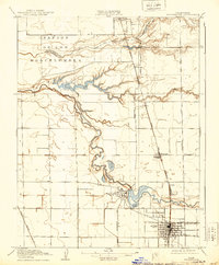
1910 Map of Woodbridge
USGS Topo · Published 1939About this map
The Mokelumne River meanders through this Central Valley landscape, its oxbows and sloughs defining the agricultural rhythm of the early 20th century. At the heart of the region, the settlement of Woodbridge sits nestled against a prominent bend in the river, while to the south, the expanding street grid of Lodi signals its emergence as a regional hub. This 1907-1908 survey captures a transition in water management, showing natural features like Tracy Lake and Smith Lake alongside the infrastructure of the Southern Pacific (Niles and Sacramento Line) and the Western Pacific railroads. Small rail stops and agricultural sidings such as Acampo, Urgon, and Jahant illustrate the importance of these transit corridors in moving produce. The northern portion of the map is dominated by the Dry Creek drainage and the historic Mexican land grant area of San Jon de los Moquelumnes, providing a detailed look at the early property boundaries and school districts, including the North School.
Find a feature on this map
24 named features on this map. Tap any name to fly to it.
Don’t see what you’re looking for? This feature index may not catch every label — zoom into the map to look around manually.
Map Details
Editions of this 1910 Woodbridge Map
2 editions found
Other maps of this area

1894 · Lodi
USGS Topo · 1:125,000

1908 · Waterloo
USGS Topo · 1:31,680

1908 · Lockeford
USGS Topo · 1:31,680

1909 · Clay
USGS Topo · 1:31,680

1910 · New Hope
USGS Topo · 1:31,680

1910 · Castle
USGS Topo · 1:31,680

1910 · Woodbridge
USGS Topo · 1:31,680

1910 · Bruceville
USGS Topo · 1:31,680

1910 · Headreach
USGS Topo · 1:31,680

1910 · Galt
USGS Topo · 1:31,680