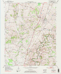
1979 Map of Woodburn
USGS Topo · Published 1984About this map
Drakes Creek and the West Fork carve through the southern landscape of this Warren and Simpson County border region, where agricultural patterns are defined by the winding waterways and the heavy transit line of the Louisville and Nashville railroad. The settlement of Woodburn serves as a local hub, featuring the Woodburn Sch and Woodburn Ch near the rail corridor. Further south, the community of Salmons sits along the road to Nashville, while institutional landmarks like the County Home and Methodist Home appear on the periphery of the established towns. The terrain is dotted with traditional country sanctuaries including Old Zion Ch and Stevenson Ch, alongside several nameless Cem sites that provide essential data for those tracing local family lineages. Industrial activity is represented by a solitary Quarry, highlighting the limestone resources characteristic of this Kentucky karst topography.
Find a feature on this map
18 named features on this map. Tap any name to fly to it.
Don’t see what you’re looking for? This feature index may not catch every label — zoom into the map to look around manually.
Map Details
Editions of this 1979 Woodburn Map
This is the sole edition of this map. No revisions or reprints were ever made.
Other maps of this area

1921 · Bowling Green
USGS Topo · 1:62,500

1923 · Bowling Green
USGS Topo · 1:62,500

1928 · Adolphus
USGS Topo · 1:48,000

1931 · Adolphus
USGS Topo · 1:62,500

1942 · Gallatin
USGS Topo · 1:100,000

1951 · Woodburn
USGS Topo · 1:24,000

1951 · Franklin
USGS Topo · 1:24,000

1951 · Prices Mill
USGS Topo · 1:24,000

1951 · Auburn
USGS Topo · 1:24,000

1951 · South Union
USGS Topo · 1:24,000