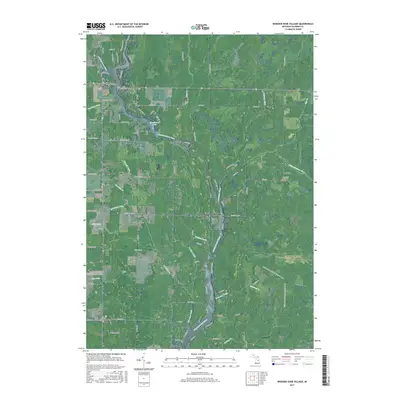
2017 Map of Wooden Shoe Village
USGS Topo · Published 2017About this map
Smallwood Lake serves as a central hydraulic hub in this portion of Gladwin County, where the Tittabawassee River and several smaller tributaries converge. The settlement pattern here is closely tied to the waterfront, with Wooden Shoe Village and White Star situated near the northern reaches of the reservoir system. The landscape is defined by an intricate network of drainage features like Babcock Drain and Van Horn Drain, which illustrate the local efforts to manage the water table for residential and agricultural use.
Find a feature on this map
75 named features on this map. Tap any name to fly to it.
Don’t see what you’re looking for? This feature index may not catch every label — zoom into the map to look around manually.
Map Details
Editions of this 2017 Wooden Shoe Village Map
This is the sole edition of this map. No revisions or reprints were ever made.
Other maps of this area

1954 · Traverse City
USGS Topo · 1:250,000

1954 · Midland
USGS Topo · 1:250,000

1958 · Traverse City
USGS Topo · 1:250,000

1958 · Midland
USGS Topo · 1:250,000

1959 · Midland
USGS Topo · 1:250,000

1966 · Midland
USGS Topo · 1:250,000

1968 · Sterling SW
USGS Topo · 1:24,000

1969 · Wagarville
USGS Topo · 1:24,000

1969 · Gladwin
USGS Topo · 1:24,000
1969 · Hope
USGS Topo · 1:24,000