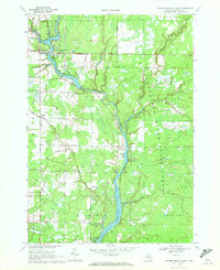
1969 Map of Wooden Shoe Village
USGS Topo · Published 1972About this map
Wooden Shoe Village and the nearby community of White Star sit at the northern reaches of the Tittabawassee River waterway system as it appeared in the late 1960s. The landscape is defined by the impounded waters behind Smallwood Dam, which created Smallwood Lake, and the upper portion of Wixom Lake further south. These reservoirs are flanked by the Tittabawassee River State Forest, showing a transition from the mid-century lumbering era toward a recreation and resource-based economy. The industrial character of the region is evident in the numerous extraction points within the Buckeye Oil Field, Highwood Field, and Mc Mahan Field. Transportation history is preserved through labels like Railroad Grade, marking former rail paths through the townships of Hay and Billings. Numerous drainage systems, such as Winegars Drain and South Buckeye Drain, reveal the managed nature of the surrounding lowlands.
Find a feature on this map
49 named features on this map. Tap any name to fly to it.
Don’t see what you’re looking for? This feature index may not catch every label — zoom into the map to look around manually.
Map Details
Editions of this 1969 Wooden Shoe Village Map
This is the sole edition of this map. No revisions or reprints were ever made.
Other maps of this area

1954 · Traverse City
USGS Topo · 1:250,000

1954 · Midland
USGS Topo · 1:250,000

1958 · Traverse City
USGS Topo · 1:250,000

1958 · Midland
USGS Topo · 1:250,000

1959 · Midland
USGS Topo · 1:250,000

1966 · Midland
USGS Topo · 1:250,000

1968 · Sterling SW
USGS Topo · 1:24,000

1969 · Wagarville
USGS Topo · 1:24,000

1969 · Gladwin
USGS Topo · 1:24,000
1969 · Hope
USGS Topo · 1:24,000