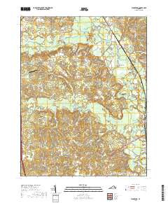
2019 Map of Woodford
USGS Topo · Published 2019About this map
Mattaponi River headwaters converge in this portion of Caroline County, where the Matta River, Poni River, and Motto River shape a landscape defined by extensive wetlands. Settlements like Woodford, Welchs, and Milford are linked by a network of rural roads such as the Fredericksburg Tpke and Ladysmith Rd. The presence of Woodford Airpark near the center of the sheet reflects the modern transportation infrastructure alongside older community landmarks. For genealogists, the map preserves the location of Bethel Cem and the small Wright's Burying Ground Cem. The terrain is punctuated by water features including Old Grays Millpond, Reedy Swamp, and Hobby Swamp, illustrating the intricate drainage patterns that have dictated local land use and development for generations.
Find a feature on this map
62 named features on this map. Tap any name to fly to it.
Don’t see what you’re looking for? This feature index may not catch every label — zoom into the map to look around manually.
Map Details
Editions of this 2019 Woodford Map
This is the sole edition of this map. No revisions or reprints were ever made.
Other maps of this area

1887 · Spottsylvania
USGS Topo · 1:125,000

1889 · Fredericksburg
USGS Topo · 1:125,000

1890 · Goochland
USGS Topo · 1:125,000

1892 · Fredericksburg
USGS Topo · 1:125,000

1892 · Spottsylvania
USGS Topo · 1:125,000

1892 · Goochland
USGS Topo · 1:125,000

1894 · Fredericksburg
USGS Topo · 1:125,000

1918 · Doswell
USGS Topo · 1:62,500

1942 · Bowling Green
USGS Topo · 1:31,680

1942 · Woodford
USGS Topo · 1:31,680