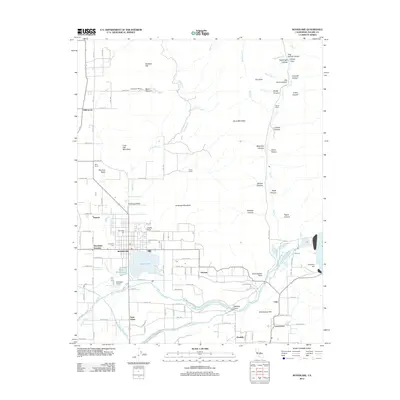
2012 Map of Woodlake
USGS Topo · Published 2012About this map
Woodlake serves as the central hub of this agricultural and citrus-growing region in Tulare County, situated at the base of the Sierra Nevada foothills. The landscape is defined by the vital water systems of the Saint Johns River and Kaweah River, which feed the surrounding valley floor and sustain Bravo Lake and the Little Bravo Lake. This survey illustrates the intricate irrigation infrastructure of the early 21st century, including the Friant-Kern Canal and Wutchumna Ditch Reservoir. Beyond the town site, smaller settlements and named locales like Naranjo, Citro, and Lemoncove trace the historical development of the local fruit industry. To the north and east, the terrain rises into landmarks such as Antelope Mountain, Sentinel Butte, and Lone Oak Mountain, where various canyons like McKee Canyon and Arrastra Canyon cut through the rugged slopes.
Find a feature on this map
100 named features on this map. Tap any name to fly to it.
Don’t see what you’re looking for? This feature index may not catch every label — zoom into the map to look around manually.
Map Details
Editions of this 2012 Woodlake Map
This is the sole edition of this map. No revisions or reprints were ever made.
Other maps of this area

1903 · Tehipite
USGS Topo · 1:125,000

1904 · Kaweah
USGS Topo · 1:125,000

1905 · Tehipite
USGS Topo · 1:125,000

1909 · Kaweah
USGS Topo · 1:125,000

1921 · Stokes Mountain
USGS Topo · 1:24,000

1922 · Trimmer
USGS Topo · 1:96,000

1924 · Dinuba
USGS Topo · 1:125,000

1924 · Stokes Mountain
USGS Topo · 1:31,680

1925 · Rocky Hill
USGS Topo · 1:31,680

1926 · Ivanhoe
USGS Topo · 1:31,680