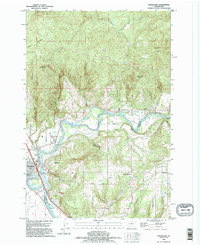
1990 Map of Woodland
USGS Topo · Published 1995About this map
The Lewis River and its meandering oxbow, Horseshoe Lake, define the riverfront character of Woodland at the junction of Cowlitz and Clark counties. This 1990s landscape illustrates a mix of valley agriculture and rising elevation, with the town center concentrated near the Woodland State Airport and various recreational and industrial landmarks like a Golf Course and Gravel Pit. The mapping highlights the transition from the flatlands of the river plain to the significant peaks of the interior, such as Devils Peak and Green Mountain.
Find a feature on this map
39 named features on this map. Tap any name to fly to it.
Don’t see what you’re looking for? This feature index may not catch every label — zoom into the map to look around manually.
Map Details
Editions of this 1990 Woodland Map
This is the sole edition of this map. No revisions or reprints were ever made.
Other maps of this area

1921 · Kalama
USGS Topo · 1:62,500

1922 · St. Helens
USGS Topo · 1:62,500

1940 · La Center
USGS Topo · 1:62,500

1941 · St Helens
USGS Topo · 1:62,500

1943 · Pigeon Springs
USGS Topo · 1:62,500

1943 · St Helens
USGS Topo · 1:62,500

1948 · Vancouver
USGS Topo · 1:250,000

1950 · Vancouver
USGS Topo · 1:250,000

1950 · Vancouver
USGS Topo · 1:250,000

1953 · Hoquiam
USGS Topo · 1:250,000