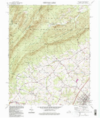
1994 Map of Woodlawn
USGS Topo · Published 1997About this map
Industrial history and rural settlement patterns converge along the state border in this mid-1990s survey. The landscape is defined by the ridge-and-valley terrain of North Mountain and Sluice Mountain, with the George Washington National Forest covering much of the northern highlands. A significant historical anchor is found at the Van Buren Furnace ruins, pointing to the region's 19th-century iron-working heritage near Cedar Creek. To the south, the valley floor transitions into a network of small communities such as St Luke, Harmony, and Coffmantown. The map provides detailed placement of local landmarks like Mount Zion Ch and the Massanutten Military Academy on the edge of Woodstock, while the narrow drainage of Passage Creek cuts through the steep gaps of the western ridges.
Find a feature on this map
51 named features on this map. Tap any name to fly to it.
Don’t see what you’re looking for? This feature index may not catch every label — zoom into the map to look around manually.
Map Details
Editions of this 1994 Woodlawn Map
This is the sole edition of this map. No revisions or reprints were ever made.
Other maps of this area

1889 · Hillsville
USGS Topo · 1:125,000

1892 · Hillsville
USGS Topo · 1:125,000

1896 · Hillsville
USGS Topo · 1:125,000

1930 · Max Meadows
USGS Topo · 1:62,500

1931 · Galax
USGS Topo · 1:48,000

1933 · Galax
USGS Topo · 1:62,500

1953 · Winston-Salem
USGS Topo · 1:250,000

1955 · Winston-Salem
USGS Topo · 1:250,000

1956 · Macks Mountain
USGS Topo · 1:62,500

1957 · Mount Airy
USGS Topo · 1:62,500