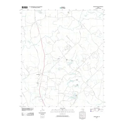
2010 Map of Woodlawn
USGS Topo · Published 2010About this map
Woodlawn and Pope City anchor this East Texas landscape, where the confluence of bayous and man-made reservoirs defines the local geography. The area's industrial and transportation history is evidenced by the Woodlawn Oil Field and the Cypress River Airport, while the intricate network of Farm to Market roads like FM 134 and FM 1793 connects the various lake communities. Water is the dominant feature of the terrain, from the slow-moving Big Cypress Bayou and Little Cypress Bayou in the north to a series of engineered water bodies including Sanders Lake, Bonita Lake, and Lake Margret. These reservoirs, often accompanied by family-named landmarks like the Sanders Lake Dam, reflect the mid-century development of the region's hydraulic resources. Genealogists and local historians can trace property boundaries and road networks such as Baker Bridge Rd and Munden Dance Hall Rd that radiate from the settlement at Woodlawn, which also includes the Woodlawn Cemetery.
Find a feature on this map
44 named features on this map. Tap any name to fly to it.
Don’t see what you’re looking for? This feature index may not catch every label — zoom into the map to look around manually.
Map Details
Editions of this 2010 Woodlawn Map
This is the sole edition of this map. No revisions or reprints were ever made.
Other maps of this area

1944 · Kildare
USGS Topo · 1:62,500

1944 · Caddo Lake
USGS Topo · 1:62,500

1946 · Caddo Lake
USGS Topo · 1:62,500

1948 · Kildare
USGS Topo · 1:62,500

1956 · Tyler
USGS Topo · 1:250,000

1962 · Kellyville
USGS Topo · 1:24,000

1962 · Marshall NW
USGS Topo · 1:24,000

1962 · Marshall West
USGS Topo · 1:24,000

1962 · Woodlawn
USGS Topo · 1:24,000
1962 · Smithland
USGS Topo · 1:24,000