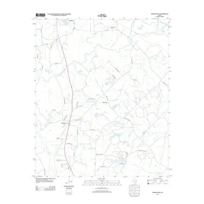
2013 Map of Woodlawn
USGS Topo · Published 2013About this map
Big Cypress Bayou and Little Cypress Bayou converge in this corner of Northeast Texas, defining a landscape shaped by water and early industry. The settlement of Woodlawn serves as a local anchor, situated near the Woodlawn Cem and the Woodlawn Oil Field, indicating the area's dual heritage of family lineage and resource extraction. Smaller community centers like Pope City and the southern edge of Jefferson appear alongside a network of rural roads such as Munden Dance Hall Rd and Owens Corner Rd. The terrain is dotted with numerous private and named water bodies including Lake Margret, Bonita Lake, and Highland Lake, suggesting a history of land management for recreation or agriculture. Aviation infrastructure is represented by the Cypress River Airport in the north, while various creeks like Beckum Cr and Holly Cr provide natural drainage for the timbered flats.
Find a feature on this map
53 named features on this map. Tap any name to fly to it.
Don’t see what you’re looking for? This feature index may not catch every label — zoom into the map to look around manually.
Map Details
Editions of this 2013 Woodlawn Map
This is the sole edition of this map. No revisions or reprints were ever made.
Other maps of this area

1944 · Kildare
USGS Topo · 1:62,500

1944 · Caddo Lake
USGS Topo · 1:62,500

1946 · Caddo Lake
USGS Topo · 1:62,500

1948 · Kildare
USGS Topo · 1:62,500

1956 · Tyler
USGS Topo · 1:250,000

1962 · Kellyville
USGS Topo · 1:24,000

1962 · Marshall NW
USGS Topo · 1:24,000

1962 · Marshall West
USGS Topo · 1:24,000

1962 · Woodlawn
USGS Topo · 1:24,000
1962 · Smithland
USGS Topo · 1:24,000