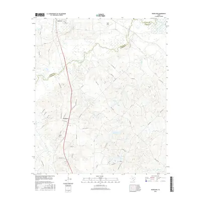
2016 Map of Woodlawn
USGS Topo · Published 2016About this map
Jefferson and the settlement of Woodlawn anchor this Northeast Texas landscape where the Marion Co and Harrison Co line divides the terrain. The northern reaches are defined by the winding course of Big Cypress Bayou and Little Cypress Bayou, creating a network of wetlands and tributaries like Grays Cr. This survey illustrates the modern residential developments such as Woodlawn Ests and Woodlawn Hills Rd, contrasted with older landmarks like the Woodlawn Cem. To the east, a dense cluster of water bodies including Highland Lake, Lake Margret, and Fern Lake highlights the importance of managed water resources in the Piney Woods region. The presence of the Cypress River Airport and a grid of rural routes like FM 134 and FM 1793 shows the local transport infrastructure supporting the region's timber and recreational economy.
Find a feature on this map
58 named features on this map. Tap any name to fly to it.
Don’t see what you’re looking for? This feature index may not catch every label — zoom into the map to look around manually.
Map Details
Editions of this 2016 Woodlawn Map
This is the sole edition of this map. No revisions or reprints were ever made.
Other maps of this area

1944 · Kildare
USGS Topo · 1:62,500

1944 · Caddo Lake
USGS Topo · 1:62,500

1946 · Caddo Lake
USGS Topo · 1:62,500

1948 · Kildare
USGS Topo · 1:62,500

1956 · Tyler
USGS Topo · 1:250,000

1962 · Kellyville
USGS Topo · 1:24,000

1962 · Marshall NW
USGS Topo · 1:24,000

1962 · Marshall West
USGS Topo · 1:24,000

1962 · Woodlawn
USGS Topo · 1:24,000
1962 · Smithland
USGS Topo · 1:24,000