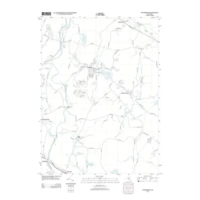
2013 Map of Woodridge
USGS Topo · Published 2013About this map
The Neversink River carves a path through this part of Sullivan County, crossed by the Neversink River Bridge as it flows south toward Bridgeville. The landscape is defined by its water, from the sprawling Wolf Lake and Pleasure Lake in the west to the smaller Katz Pond and Bowers Pond further south. Local settlements are scattered throughout the region, including the village of Woodridge and the hamlet of Mountain Dale, both situated near the winding Sandburg Cr.
Find a feature on this map
135 named features on this map. Tap any name to fly to it.
Don’t see what you’re looking for? This feature index may not catch every label — zoom into the map to look around manually.
Map Details
Editions of this 2013 Woodridge Map
This is the sole edition of this map. No revisions or reprints were ever made.
Other maps of this area

1903 · Slide Mountain
USGS Topo · 1:62,500

1904 · Ellenville
USGS Topo · 1:62,500

1905 · Slide Mountain
USGS Topo · 1:62,500

1906 · Ellenville
USGS Topo · 1:62,500

1909 · Monticello
USGS Topo · 1:62,500

1910 · Neversink
USGS Topo · 1:62,500

1911 · Monticello
USGS Topo · 1:62,500

1942 · Neversink
USGS Topo · 1:62,500

1942 · Lackawack
USGS Topo · 1:24,000
1942 · Ellenville
USGS Topo · 1:24,000