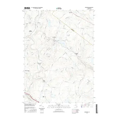
2016 Map of Woodridge
USGS Topo · Published 2016About this map
Woodridge and the surrounding Catskills foothills are defined by a network of small settlements and clear mountain waters in this 2016 survey. The village of Woodridge sits at the heart of the map, while South Fallsburg and Fallsburg occupy the northwestern corner along the banks of the Neversink River. These communities are connected by a web of local routes like Old Turnpike Rd and Mountain Dale Rd, reflecting a landscape shaped by seasonal tourism and residential growth. Notable landmarks including Yeshivath Zichron Moshe and the Neversink River Bridge highlight the intersection of cultural institutions and civil engineering in this portion of Sullivan County.
Find a feature on this map
124 named features on this map. Tap any name to fly to it.
Don’t see what you’re looking for? This feature index may not catch every label — zoom into the map to look around manually.
Map Details
Editions of this 2016 Woodridge Map
This is the sole edition of this map. No revisions or reprints were ever made.
Other maps of this area

1903 · Slide Mountain
USGS Topo · 1:62,500

1904 · Ellenville
USGS Topo · 1:62,500

1905 · Slide Mountain
USGS Topo · 1:62,500

1906 · Ellenville
USGS Topo · 1:62,500

1909 · Monticello
USGS Topo · 1:62,500

1910 · Neversink
USGS Topo · 1:62,500

1911 · Monticello
USGS Topo · 1:62,500

1942 · Neversink
USGS Topo · 1:62,500

1942 · Lackawack
USGS Topo · 1:24,000
1942 · Ellenville
USGS Topo · 1:24,000