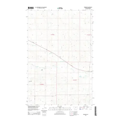
2014 Map of Woodrow
USGS Topo · Published 2014About this map
Woodrow sits as a central point of reference in this Dawson County landscape, where the high plains are carved by an intricate network of seasonal drainages and coulees. The terrain is defined by the winding course of Upper Sevenmile Cr and Timber Fork, which cut through the undulating ranch land. Ranching and water management are evident through the numerous small impoundments scattered across the township lines, including Deer Creek Reservoir, Malkuch Reservoir, and Jack Downs Reservoir. These features, along with the deep relief of Wolf Coulee, illustrate the vital role of water collection in this semi-arid region. The map also traces local transit corridors such as MT-200s and several section-line roads, providing a clear picture of the rural infrastructure and land divisions that have organized this part of Montana into the modern era.
Find a feature on this map
19 named features on this map. Tap any name to fly to it.
Don’t see what you’re looking for? This feature index may not catch every label — zoom into the map to look around manually.
Map Details
Editions of this 2014 Woodrow Map
This is the sole edition of this map. No revisions or reprints were ever made.
Other maps of this area

1909 · Glendive
USGS Topo · 1:250,000

1954 · Glendive
USGS Topo · 1:250,000

1957 · Glendive
USGS Topo · 1:250,000

1958 · Glendive
USGS Topo · 1:250,000
1972 · Pleasant View
USGS Topo · 1:24,000

1972 · Poverty Flat West
USGS Topo · 1:24,000

1972 · Stinking Coulee
USGS Topo · 1:24,000

1981 · Glendive
USGS Topo · 1:100,000

1982 · Circle
USGS Topo · 1:100,000
1983 · Johnson Reservoir
USGS Topo · 1:24,000