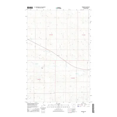
2017 Map of Woodrow
USGS Topo · Published 2017About this map
Woodrow sits at the heart of this Dawson County landscape, where the drainage systems of the Montana plains define the local geography. The area is marked by a network of seasonal watercourses and reservoirs, most notably Jack Downs Reservoir and Molkuch Reservoir, which serve as vital water management points in an otherwise arid environment. The terrain is deeply carved by features like Wolf Coulee, while the flow of Timber Fork and Upper Sevenmile Cr dictates the movement of cattle and commerce. This survey details the transition between Township 16 North and 17 North, illustrating how section lines and local routes like Rd 230 and Rd 437 impose order on the natural contours of the northern plains.
Find a feature on this map
17 named features on this map. Tap any name to fly to it.
Don’t see what you’re looking for? This feature index may not catch every label — zoom into the map to look around manually.
Map Details
Editions of this 2017 Woodrow Map
This is the sole edition of this map. No revisions or reprints were ever made.
Other maps of this area

1909 · Glendive
USGS Topo · 1:250,000

1954 · Glendive
USGS Topo · 1:250,000

1957 · Glendive
USGS Topo · 1:250,000

1958 · Glendive
USGS Topo · 1:250,000
1972 · Pleasant View
USGS Topo · 1:24,000

1972 · Poverty Flat West
USGS Topo · 1:24,000

1972 · Stinking Coulee
USGS Topo · 1:24,000

1981 · Glendive
USGS Topo · 1:100,000

1982 · Circle
USGS Topo · 1:100,000
1983 · Johnson Reservoir
USGS Topo · 1:24,000