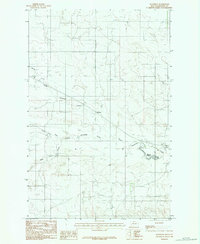
1983 Map of Woodrow
USGS Topo · Published 1983About this map
Woodrow sits at the heart of this high plains landscape in Dawson County, where the intricate drainage patterns of the Missouri River watershed shape the local geography. The map documents a sparsely settled ranching or farming region defined by the winding course of Upper Sevenmile Creek and its downstream continuation, Sevenmile Creek. These waterways, along with Spring Creek and the seasonal runoff captured in Wolf Coulee, illustrate the vital importance of water management in eastern Montana. A notable man-made feature is the Malkuch Reservoir, providing a clear focal point for agricultural or livestock activity in the southeastern quadrant. This provisional survey captures the area as it appeared in the early 1980s, preserving the locations of isolated rural homesteads and the essential network of improved and unimproved roads that connected this community to the wider region.
Find a feature on this map
6 named features on this map. Tap any name to fly to it.
Don’t see what you’re looking for? This feature index may not catch every label — zoom into the map to look around manually.
Map Details
Editions of this 1983 Woodrow Map
This is the sole edition of this map. No revisions or reprints were ever made.
Other maps of this area

1909 · Glendive
USGS Topo · 1:250,000

1954 · Glendive
USGS Topo · 1:250,000

1957 · Glendive
USGS Topo · 1:250,000

1958 · Glendive
USGS Topo · 1:250,000
1972 · Pleasant View
USGS Topo · 1:24,000

1972 · Poverty Flat West
USGS Topo · 1:24,000

1972 · Stinking Coulee
USGS Topo · 1:24,000

1981 · Glendive
USGS Topo · 1:100,000

1982 · Circle
USGS Topo · 1:100,000
1983 · Johnson Reservoir
USGS Topo · 1:24,000