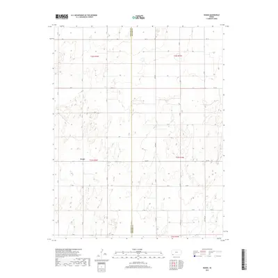
2018 Map of Woods
USGS Topo · Published 2018About this map
The small community of Woods anchors this High Plains landscape along the boundary of Stevens and Seward Counties. Surveyed in 2018, the map illustrates the systematic sectional layout of the Kansas prairie, where the transition between Stevens Co Seward Co is marked by a network of rural routes such as Marteney and Wettstein Rd. The terrain is characterized by numerous small depressions and drainage patterns typical of the region's semi-arid environment. The lack of concentrated development outside of Woods emphasizes the area's agricultural focus, with the land divided into precise townships including t33s r35w and t33s r34w. This sheet provides an exact view of the modern road system, including named county thoroughfares like Co Rd 9 and Co Rd C, which facilitate movement through this remote ranching and farming territory.
Find a feature on this map
32 named features on this map. Tap any name to fly to it.
Don’t see what you’re looking for? This feature index may not catch every label — zoom into the map to look around manually.
Map Details
Editions of this 2018 Woods Map
This is the sole edition of this map. No revisions or reprints were ever made.
Other maps of this area

1944 · Moscow
USGS Topo · 1:62,500

1945 · Moscow
USGS Topo · 1:62,500

1955 · Dodge City
USGS Topo · 1:250,000

1958 · Dodge City
USGS Topo · 1:250,000

1959 · Dodge City
USGS Topo · 1:250,000

1968 · Sublette SW
USGS Topo · 1:24,000

1968 · Liberal NW
USGS Topo · 1:24,000

1971 · Liberal
USGS Topo · 1:24,000
1974 · Woods SW
USGS Topo · 1:24,000
1974 · Woods SE
USGS Topo · 1:24,000