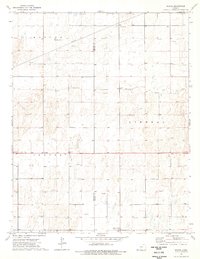
1974 Map of Woods
USGS Topo · Published 1976About this map
The High Plains of Southwest Kansas are defined here by a systematic grid of pipelines and numerous gas wells, illustrating the intensive energy development across Stevens and Seward Counties in the mid-1970s. The small settlement of Woods serves as a central point along the sectional roads, while the surrounding landscape is marked by community landmarks such as Lone Star Ch and the Pleasant Valley Community Hall. This survey captures the transition of the prairie into a hub of extraction and utility, where natural resource infrastructure like the Sandpit and various energy conduits integrate with traditional rural life. The topography is subtle, showing the wide expanses within the Center, Liberal, and Banner townships before modern irrigation further altered the surface patterns.
Find a feature on this map
11 named features on this map. Tap any name to fly to it.
Don’t see what you’re looking for? This feature index may not catch every label — zoom into the map to look around manually.
Map Details
Editions of this 1974 Woods Map
This is the sole edition of this map. No revisions or reprints were ever made.
Other maps of this area

1944 · Moscow
USGS Topo · 1:62,500

1945 · Moscow
USGS Topo · 1:62,500

1955 · Dodge City
USGS Topo · 1:250,000

1958 · Dodge City
USGS Topo · 1:250,000

1959 · Dodge City
USGS Topo · 1:250,000

1968 · Sublette SW
USGS Topo · 1:24,000

1968 · Liberal NW
USGS Topo · 1:24,000

1971 · Liberal
USGS Topo · 1:24,000
1974 · Woods SW
USGS Topo · 1:24,000
1974 · Woods SE
USGS Topo · 1:24,000