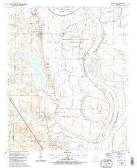
1987 Map of Woodson
USGS Topo · Published 1988About this map
Wrightsville and the surrounding river bottomlands of the Arkansas River define this mid-1980s topographic portrait. The landscape is heavily influenced by the meandering river, featuring dramatic bends like Warings Bend and a network of water bodies including Georgetown Lake and Lake Kuykendall. This era shows a community structured around both the Arkansas Department of Corrections and a series of rural clusters like Woodson and Hensley.
Find a feature on this map
55 named features on this map. Tap any name to fly to it.
Don’t see what you’re looking for? This feature index may not catch every label — zoom into the map to look around manually.
Map Details
Editions of this 1987 Woodson Map
2 editions found
Other maps of this area

1891 · Little Rock
USGS Topo · 1:125,000

1893 · Little Rock
USGS Topo · 1:125,000

1932 · Pastoria
USGS Topo · 1:62,500

1935 · Little Rock
USGS Topo · 1:24,000

1935 · Sweet Home
USGS Topo · 1:24,000

1935 · Alexander
USGS Topo · 1:48,000

1935 · Pastoria
USGS Topo · 1:62,500

1939 · Keo
USGS Topo · 1:31,680

1940 · Woodson
USGS Topo · 1:31,680

1941 · Alexander
USGS Topo · 1:62,500