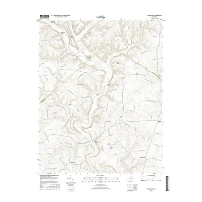
2016 Map of Woodstock
USGS Topo · Published 2016About this map
Buck Creek and its many winding tributaries like Glade Fork Cr and Whetstone Cr carve through this landscape along the Lincoln and Pulaski county line. The map highlights a rural Kentucky settlement pattern defined by small communities such as Goochtown, Albia, and Woodstock that grew around early schools and local crossroads. Evidence of family history is prominent through numerous burial sites including Goodhope Cem, Friendship Cem, and Harness Cem. The terrain is marked by distinct high points like Warren Knob and Purcell Knob, while the inclusion of Short Airport near Clarence reflects the modern integration of aviation into this traditional agricultural and residential region. Researchers will find a dense network of local routes, such as Broughtontown School Rd and Old Bee Lick Rd, that follow the ridges and hollows.
Find a feature on this map
124 named features on this map. Tap any name to fly to it.
Don’t see what you’re looking for? This feature index may not catch every label — zoom into the map to look around manually.
Map Details
Editions of this 2016 Woodstock Map
This is the sole edition of this map. No revisions or reprints were ever made.
Other maps of this area

1893 · London
USGS Topo · 1:125,000

1897 · London
USGS Topo · 1:125,000

1935 · Somerset
USGS Topo · 1:62,500

1952 · Halls Gap
USGS Topo · 1:24,000

1952 · Eubank
USGS Topo · 1:24,000

1952 · Crab Orchard
USGS Topo · 1:24,000

1952 · Shopville
USGS Topo · 1:24,000

1952 · Woodstock
USGS Topo · 1:24,000

1953 · Maretburg
USGS Topo · 1:24,000
1953 · Brodhead
USGS Topo · 1:24,000