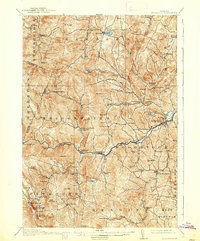
1913 Map of Woodstock
USGS Topo · Published 1938About this map
Woodstock serves as the focal point for this early twentieth-century survey of the Green Mountains, where the Woodstock RR terminates along the Ottanquechee River. The landscape is a network of small upland settlements and valley hamlets connected by winding roads through steep terrain like Delectable Mountain and The Gulf. Evidence of early Vermont community life is widespread, featuring numerous rural educational outposts such as the Stony Brook School and Mendall School, alongside the Town Farm in Woodstock. Local industry and mail services are represented by English Mills and the Bridgewater Center Briggs PO. Further south, the map details the terrain around Plymouth Notch and Plymouth Union, capturing a snapshot of the region's agricultural and village structure before the mid-century shifts in rural population.
Find a feature on this map
93 named features on this map. Tap any name to fly to it.
Don’t see what you’re looking for? This feature index may not catch every label — zoom into the map to look around manually.
Map Details
Editions of this 1913 Woodstock Map
5 editions found
Other maps of this area

1891 · Rutland
USGS Topo · 1:62,500

1893 · Wallingford
USGS Topo · 1:62,500

1893 · Rutland
USGS Topo · 1:62,500

1896 · Strafford
USGS Topo · 1:62,500

1906 · Hanover
USGS Topo · 1:62,500

1908 · Hanover
USGS Topo · 1:62,500

1911 · Woodstock
USGS Topo · 1:62,500

1913 · Woodstock
USGS Topo · 1:62,500

1915 · Rochester
USGS Topo · 1:62,500

1917 · Rochester
USGS Topo · 1:62,500