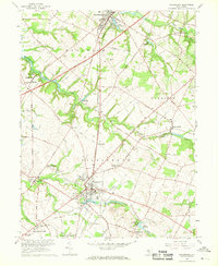
1967 Map of Woodstown
USGS Topo · Published 1968About this map
The Salem River and Oldmans Creek define the agricultural and residential landscape of this South Jersey region in the late 1960s. Woodstown serves as a central hub, where the Shoemaker Sch and High Sch stand near the shores of Memorial Lake. The transportation network is anchored by the Pennsylvania-Reading Seashore Lines, which bisect the landscape vertically, connecting northern settlements like Swedesboro to the rural townships of Pilesgrove and South Harrison. Smaller crossroads and hamlets such as Harrisonville, Sharptown, and Auburn are dispersed throughout, often centered near water-powered features like Porches Mill or Avis Millpond. This survey illustrates the transition from a traditional milling and farming economy toward modern infrastructure, with the New Jersey Toll Road cutting across the western corner of the quadrangle while local routes like Kings Highway maintain the area's older connectivity.
Find a feature on this map
70 named features on this map. Tap any name to fly to it.
Don’t see what you’re looking for? This feature index may not catch every label — zoom into the map to look around manually.
Map Details
Editions of this 1967 Woodstown Map
2 editions found
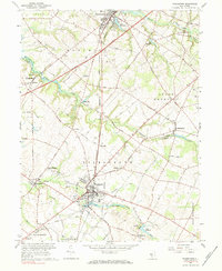
Other maps of this area

1890 · Salem
USGS Topo · 1:62,500

1890 · Glassboro
USGS Topo · 1:62,500

1891 · Philadelphia
USGS Topo · 1:62,500

1894 · Chester
USGS Topo · 1:62,500

1894 · Philadelphia
USGS Topo · 1:62,500

1896 · Philadelphia
USGS Topo · 1:62,500

1896 · Chester
USGS Topo · 1:62,500

1898 · Salem
USGS Topo · 1:62,500

1898 · Glassboro
USGS Topo · 1:62,500

1898 · Chester
USGS Topo · 1:62,500