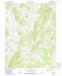
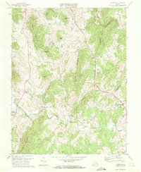
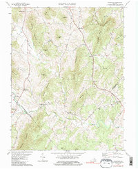
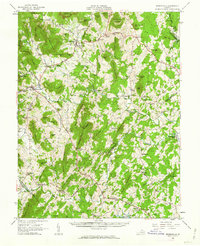
1971 Map of Woodville
USGS Topo · Published 1986About this map
Woodville sits at the heart of this Piedmont landscape, where the rolling foothills meet the Blue Ridge mountains. The map documents a rural Virginia economy defined by the confluence of the Hazel River and Hughes River, featuring a network of crossroads settlements and small-scale infrastructure. Distinctive topographic features like Red Oak Mountain, Bessie Bell Mountain, and Slaughter Mtn dominate the horizon, while the lowlands are dotted with community landmarks. Genealogists and local historians can trace family locations through named sites such as Revercombs Corner and Buckners Corner, along with traditional places of worship including Piedmont Ch, Mt Lebanon Ch, and Nazareth Ch. The presence of Peola Mills and Slate Mills indicates the historical importance of water-powered industry along the riverbanks, even as a modern Landing Strip appears near Jobbers Mountain.
Find a feature on this map
41 named features on this map. Tap any name to fly to it.
Don’t see what you’re looking for? This feature index may not catch every label — zoom into the map to look around manually.
Map Details
Editions of this 1971 Woodville Map
Other maps of this area

1892 · Gordonsville
USGS Topo · 1:125,000

1893 · Luray
USGS Topo · 1:125,000

1905 · Luray
USGS Topo · 1:125,000

1929 · Stony Man
USGS Topo · 1:48,000

1930 · Madison
USGS Topo · 1:48,000

1933 · Stony Man
USGS Topo · 1:62,500

1933 · Madison
USGS Topo · 1:62,500

1949 · Charlottesville
USGS Topo · 1:250,000

1956 · Charlottesville
USGS Topo · 1:250,000
1961 · Sperryville
USGS Topo · 1:62,500