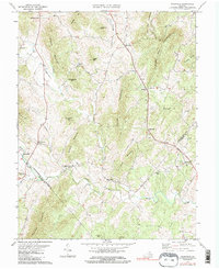
1971 Map of Woodville
USGS Topo · Published 1986About this map
The Hazel River and Hughes River define the valley corridors of this northern Virginia landscape, where small crossroads communities serve as anchors for the surrounding rural territory. Near the center of the sheet, Woodville and Scrabble sit along the primary road network, while smaller nodes like Peola Mills and Slate Mills suggest a historical reliance on water power along the local runs. The map documents numerous rural landmarks essential for genealogical research, including Piedmont Ch, Mt Lebanon Ch, and Nazareth Ch, alongside many unnamed family burial grounds marked simply as Cem. High peaks like Slaughter Mtn, Jobbers Mountain, and Bessie Bell Mountain ring the valleys, illustrating the physical constraints that shaped the settlement patterns of Rappahannock, Madison, and Culpeper Counties during the mid-20th century.
Find a feature on this map
42 named features on this map. Tap any name to fly to it.
Don’t see what you’re looking for? This feature index may not catch every label — zoom into the map to look around manually.
Map Details
Editions of this 1971 Woodville Map
Other maps of this area

1892 · Gordonsville
USGS Topo · 1:125,000

1893 · Luray
USGS Topo · 1:125,000

1905 · Luray
USGS Topo · 1:125,000

1929 · Stony Man
USGS Topo · 1:48,000

1930 · Madison
USGS Topo · 1:48,000

1933 · Stony Man
USGS Topo · 1:62,500

1933 · Madison
USGS Topo · 1:62,500

1949 · Charlottesville
USGS Topo · 1:250,000

1956 · Charlottesville
USGS Topo · 1:250,000

1961 · Sperryville
USGS Topo · 1:62,500