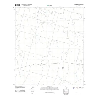
2010 Map of Woodward NE
USGS Topo · Published 2010About this map
Covey Chapel Cemetery stands as a primary historical landmark in this corner of Frio County, marking a site of local genealogical interest amidst the ranching landscape of South Texas. The area is defined by the drainage networks of Cibolo Creek and its intermittent tributary, Dry Cibolo Creek, which weave through a grid of rural roads named for local families and landmarks. The transportation network, including Ventura Rd and Hugo Rd, supports the agricultural and aviation operations centered at the McDonald Ranch Airport. This landscape, documented in the early 21st century, illustrates the enduring spatial patterns of Texas ranch land where development is concentrated along named branches like the Mitchell Branch and named rural routes.
Find a feature on this map
31 named features on this map. Tap any name to fly to it.
Don’t see what you’re looking for? This feature index may not catch every label — zoom into the map to look around manually.
Map Details
Editions of this 2010 Woodward NE Map
This is the sole edition of this map. No revisions or reprints were ever made.
Other maps of this area

1925 · Pearsall 1-c
USGS Topo · 1:48,000

1927 · Pearsall
USGS Topo · 1:62,500

1942 · Divot
USGS Topo · 1:62,500

1942 · Dilley
USGS Topo · 1:62,500

1953 · Crystal City
USGS Topo · 1:250,000

1955 · Crystal City
USGS Topo · 1:250,000

1956 · Woodward
USGS Topo · 1:62,500

1956 · Divot
USGS Topo · 1:62,500

1961 · Crystal City
USGS Topo · 1:250,000
1964 · Derby
USGS Topo · 1:24,000