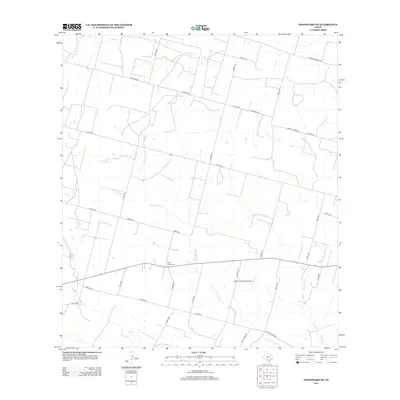
2013 Map of Woodward NE
USGS Topo · Published 2013About this map
Dry Cibolo Cr and Cibolo Cr define the hydrological character of this Frio County landscape, where seasonal watercourses and local drainage basins intersect an extensive network of rural ranch roads. The territory is marked by a legacy of family ranching and small-scale aviation, exemplified by the Mc Donald Ranch Airport situated north of Copps Rd. Near the center of the sheet, the Covey Chapel Cem remains as a focal point for local genealogy and history, positioned along the east-west corridor of a primary local thoroughfare. The map reveals a transition from natural creek beds like Big Hollow Cr to the ordered grid of county roads such as Ventura Rd and Urban Rd, illustrating the spatial organization of South Texas ranchlands in the early 21st century.
Find a feature on this map
37 named features on this map. Tap any name to fly to it.
Don’t see what you’re looking for? This feature index may not catch every label — zoom into the map to look around manually.
Map Details
Editions of this 2013 Woodward NE Map
This is the sole edition of this map. No revisions or reprints were ever made.
Other maps of this area

1925 · Pearsall 1-c
USGS Topo · 1:48,000

1927 · Pearsall
USGS Topo · 1:62,500

1942 · Divot
USGS Topo · 1:62,500

1942 · Dilley
USGS Topo · 1:62,500

1953 · Crystal City
USGS Topo · 1:250,000

1955 · Crystal City
USGS Topo · 1:250,000

1956 · Woodward
USGS Topo · 1:62,500

1956 · Divot
USGS Topo · 1:62,500

1961 · Crystal City
USGS Topo · 1:250,000
1964 · Derby
USGS Topo · 1:24,000