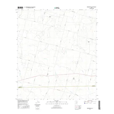
2016 Map of Woodward NE
USGS Topo · Published 2016About this map
The south Texas cattle country of Frio County is defined by its seasonal drainages and sprawling ranch properties in this 2016 survey. The landscape is primarily shaped by the winding courses of Cibolo Cr and Dry Cibolo Cr, which cut through the terrain alongside secondary waterways like Mitchell Br and Snake Cr. Settlement here is sparse and deeply tied to the land's topography, with named geographic features such as Big Hollow and Panther Hollow providing orientation. Transportation is dominated by a grid of county roads, including Co RD 4700 and Urban Rd, which connect the remote ranch sites. A significant local landmark is the Covey Chapel Cem, serving as a vital touchstone for genealogists and local historians researching families from the Frio Co and La Salle Co borderlands. The presence of the Mc Donald Ranch Airport reflects the continued importance of private aviation in managing these expansive south Texas rangelands.
Find a feature on this map
41 named features on this map. Tap any name to fly to it.
Don’t see what you’re looking for? This feature index may not catch every label — zoom into the map to look around manually.
Map Details
Editions of this 2016 Woodward NE Map
This is the sole edition of this map. No revisions or reprints were ever made.
Other maps of this area

1925 · Pearsall 1-c
USGS Topo · 1:48,000

1927 · Pearsall
USGS Topo · 1:62,500

1942 · Divot
USGS Topo · 1:62,500

1942 · Dilley
USGS Topo · 1:62,500

1953 · Crystal City
USGS Topo · 1:250,000

1955 · Crystal City
USGS Topo · 1:250,000

1956 · Woodward
USGS Topo · 1:62,500

1956 · Divot
USGS Topo · 1:62,500

1961 · Crystal City
USGS Topo · 1:250,000
1964 · Derby
USGS Topo · 1:24,000