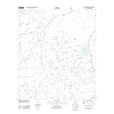
2012 Map of Woodworth West
USGS Topo · Published 2012About this map
Castor Plunge and the surrounding piney woods of Rapides Parish are defined by an intricate network of creeks and bayous. This area, largely comprised of forest service lands, is traversed by timber roads and historic routes such as Messina Rd and Hamp Smith Rd. The landscape is dominated by water features, from the large Kincaid Reservoir in the northwest to the winding Bayou Boeuf and its associated Bayou Boeuf Natural Research Area. Local history is visible in the placement of Evangeline Camp and the institutional presence of Woodworth Airport. To the east, the terrain transitions toward more managed landscapes, evidenced by the Oden Lake area and neighboring memorial parks. The abundance of named drainages like Little Loving Cr, Big Brushy Cr, and Little Bayou Clear reflects the complex hydrology of this central Louisiana corridor.
Find a feature on this map
37 named features on this map. Tap any name to fly to it.
Don’t see what you’re looking for? This feature index may not catch every label — zoom into the map to look around manually.
Map Details
Editions of this 2012 Woodworth West Map
This is the sole edition of this map. No revisions or reprints were ever made.
Other maps of this area

1932 · Boyce SW
USGS Topo · 1:31,680

1935 · Lecompte
USGS Topo · 1:62,500

1941 · Alexandria
USGS Topo · 1:62,500

1941 · Boyce
USGS Topo · 1:62,500

1945 · Boyce SE
USGS Topo · 1:31,680

1949 · Boyce SE
USGS Topo · 1:31,680

1953 · Alexandria
USGS Topo · 1:250,000

1955 · Alexandria
USGS Topo · 1:250,000

1956 · Forest Hill
USGS Topo · 1:62,500

1956 · Boyce
USGS Topo · 1:62,500