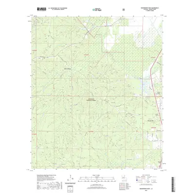
2020 Map of Woodworth West
USGS Topo · Published 2020About this map
Kisatchie National Forest dominates the landscape of Rapides Parish, where a intricate network of creeks and bayous defines the terrain. The central portion of the map is marked by the winding courses of Castor Cr and Boggy Bayou, which feed into the wetlands and lowlands characteristic of this region. The settlement of Castor Plunge sits at the intersection of several forest routes, illustrating the historic reliance on timber and natural resource management in central Louisiana. To the east, the town of Woodworth serves as a local hub, situated near Woodworth Airport and the expansive Alexander Memorial Gardens. The cartography also details the local hydrology, including Oden Lake and the prominent Bayou Boeuf, alongside the many forest roads and trails like Wild Azalea that weave through the pine-covered ridges.
Find a feature on this map
60 named features on this map. Tap any name to fly to it.
Don’t see what you’re looking for? This feature index may not catch every label — zoom into the map to look around manually.
Map Details
Editions of this 2020 Woodworth West Map
This is the sole edition of this map. No revisions or reprints were ever made.
Other maps of this area

1932 · Boyce SW
USGS Topo · 1:31,680

1935 · Lecompte
USGS Topo · 1:62,500

1941 · Alexandria
USGS Topo · 1:62,500

1941 · Boyce
USGS Topo · 1:62,500

1945 · Boyce SE
USGS Topo · 1:31,680

1949 · Boyce SE
USGS Topo · 1:31,680

1953 · Alexandria
USGS Topo · 1:250,000

1955 · Alexandria
USGS Topo · 1:250,000

1956 · Forest Hill
USGS Topo · 1:62,500

1956 · Boyce
USGS Topo · 1:62,500