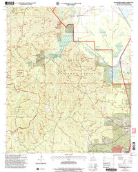
2003 Map of Woodworth West
USGS Topo · Published 2005About this map
Kisatchie National Forest dominates this Central Louisiana landscape, where the managed timberlands are punctuated by a complex network of bayous and recreational infrastructure. The 2003 revision reveals a region defined by contrasting land uses, from the Castor Creek Scenic Area and the Bayou Boeuf Natural Research Area to the extensive Claiborne Air-To-Ground Weapons Range. The Wild Azalea Trail and Evangeline Camp Trail wind through the topography, connecting landmarks like Kincaid Reservoir with the headwaters of Boggy Bayou and Castor Plunge Creek. Near the settlement of Woodworth, the landscape shifts toward industry and civic utility with numerous Gravel Pits, Water Tanks, and memorial grounds including Sunrise Memorial Gardens. This map documents a unique intersection of federal conservation, military training, and the expanding outskirts of Rapides Parish.
Find a feature on this map
44 named features on this map. Tap any name to fly to it.
Don’t see what you’re looking for? This feature index may not catch every label — zoom into the map to look around manually.
Map Details
Editions of this 2003 Woodworth West Map
This is the sole edition of this map. No revisions or reprints were ever made.
Other maps of this area

1932 · Boyce SW
USGS Topo · 1:31,680

1935 · Lecompte
USGS Topo · 1:62,500

1941 · Alexandria
USGS Topo · 1:62,500

1941 · Boyce
USGS Topo · 1:62,500

1945 · Boyce SE
USGS Topo · 1:31,680

1949 · Boyce SE
USGS Topo · 1:31,680

1953 · Alexandria
USGS Topo · 1:250,000

1955 · Alexandria
USGS Topo · 1:250,000

1956 · Forest Hill
USGS Topo · 1:62,500

1956 · Boyce
USGS Topo · 1:62,500