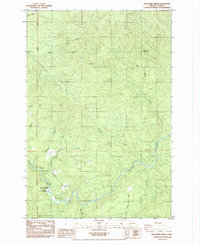
1985 Map of Woolford Creek
USGS Topo · Published 1985About this map
The Kalama River snakes through this 1985 landscape in Cowlitz County, characterized by a series of drainages and industrial extractive sites. In the southwestern corner, the Kalama Falls Salmon Hatchery and Lower Kalama River Falls mark a significant point along the watercourse where the Willamette Meridian defines the western edge of the survey. Numerous industrial Borrow Pits are scattered across the terrain, indicating active resource extraction during the mid-1980s.
Find a feature on this map
18 named features on this map. Tap any name to fly to it.
Don’t see what you’re looking for? This feature index may not catch every label — zoom into the map to look around manually.
Map Details
Editions of this 1985 Woolford Creek Map
2 editions found
Other maps of this area

1921 · Kalama
USGS Topo · 1:62,500

1922 · St. Helens
USGS Topo · 1:62,500

1940 · La Center
USGS Topo · 1:62,500

1941 · St Helens
USGS Topo · 1:62,500

1943 · Pigeon Springs
USGS Topo · 1:62,500

1943 · St Helens
USGS Topo · 1:62,500

1948 · Vancouver
USGS Topo · 1:250,000

1950 · Vancouver
USGS Topo · 1:250,000

1950 · Vancouver
USGS Topo · 1:250,000

1953 · Hoquiam
USGS Topo · 1:250,000