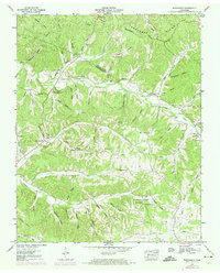
1952 Map of Woolworth
USGS Topo · Published 1974About this map
The Tennessee Valley Authority and USGS documented this pocket of the Western Highland Rim where the Houston and Humphreys County line crosses a landscape defined by deep drainage patterns. The settlement at Woolworth and the crossroads of Silvertop serve as the primary human hubs in a region dominated by intricate hollows and ridges. This survey provides remarkable detail for genealogists, mapping numerous family-named burial grounds including Batson Cem, Adams Cem, and Cleghern Cem.
Find a feature on this map
86 named features on this map. Tap any name to fly to it.
Don’t see what you’re looking for? This feature index may not catch every label — zoom into the map to look around manually.
Map Details
Editions of this 1952 Woolworth Map
3 editions found
Other maps of this area

1931 · Erin
USGS Topo · 1:62,500

1936 · Gorman
USGS Topo · 1:24,000

1936 · Tantrough Hollow
USGS Topo · 1:24,000

1936 · Woolworth
USGS Topo · 1:24,000

1936 · Ruskin
USGS Topo · 1:24,000

1936 · Stewart
USGS Topo · 1:24,000

1936 · Halls Creek
USGS Topo · 1:24,000

1936 · Waverly
USGS Topo · 1:24,000

1936 · Tennessee City
USGS Topo · 1:24,000

1950 · Halls Creek
USGS Topo · 1:24,000