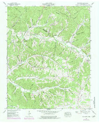
1952 Map of Woolworth
USGS Topo · Published 1983About this map
The Tennessee Valley Divide snakes through this high country on the border of Houston and Humphreys counties, dictating the flow of numerous hollows and branches in the mid-20th century. The settlement of Woolworth serves as a local hub near the Pinhook Branch, while the small community of Silvertop sits further east along the divide. This landscape is defined by its deep drainage patterns, with names like Mule Lot Hollow and Sugarcamp Hollow reflecting a history of small-scale agricultural use and timber harvesting. Genealogists will find a high density of family-named landmarks and burial sites, including the Batson Cem and Cleghorn Cem. Rural spiritual life is centered around several modest congregations, most notably New Hope Ch and Pleasant Ridge Ch, which were often positioned on higher ground away from the flood-prone creek bottoms.
Find a feature on this map
83 named features on this map. Tap any name to fly to it.
Don’t see what you’re looking for? This feature index may not catch every label — zoom into the map to look around manually.
Map Details
Editions of this 1952 Woolworth Map
3 editions found
Other maps of this area

1931 · Erin
USGS Topo · 1:62,500

1936 · Gorman
USGS Topo · 1:24,000

1936 · Tantrough Hollow
USGS Topo · 1:24,000

1936 · Woolworth
USGS Topo · 1:24,000

1936 · Ruskin
USGS Topo · 1:24,000

1936 · Stewart
USGS Topo · 1:24,000

1936 · Halls Creek
USGS Topo · 1:24,000

1936 · Waverly
USGS Topo · 1:24,000

1936 · Tennessee City
USGS Topo · 1:24,000

1950 · Halls Creek
USGS Topo · 1:24,000