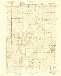
1940 Map of Worland
USGS Topo · Published 1940About this map
Amoret and Worland anchor this 1940 survey of the western Missouri border, where the Linn Co Bates Co line separates Missouri from Kansas. The landscape is defined by the winding course of the Osage River and a dense network of early rural infrastructure. Small-scale coal mining and agriculture are evidenced by the numerous local schools and cemeteries that served these tight-knit communities. The transit corridor is particularly busy, with the Kansas City Southern and Missouri Pacific railroads running parallel north-to-south, facilitating movement through the Valley. Researchers will find significant genealogical value in the distribution of rural landmarks, from the Salem Cem and Mays Cem to the scattered educational centers like Victory Sch and Johnson Sch that dot the townships of Homer and Charlotte.
Find a feature on this map
35 named features on this map. Tap any name to fly to it.
Don’t see what you’re looking for? This feature index may not catch every label — zoom into the map to look around manually.
Map Details
Editions of this 1940 Worland Map
2 editions found
Other maps of this area

1887 · Butler
USGS Topo · 1:125,000

1887 · Mound City
USGS Topo · 1:125,000

1893 · Mound City
USGS Topo · 1:125,000

1894 · Butler
USGS Topo · 1:125,000

1937 · New Home
USGS Topo · 1:24,000

1938 · Worland
USGS Topo · 1:24,000

1940 · Worland
USGS Topo · 1:24,000

1940 · Hume
USGS Topo · 1:24,000

1942 · Hume
USGS Topo · 1:24,000
1942 · Sprague
USGS Topo · 1:24,000