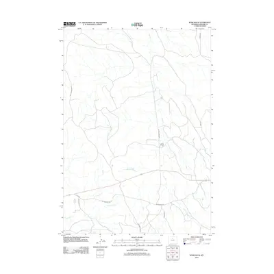
2012 Map of Worland SE
USGS Topo · Published 2012About this map
Tolman Shearing Pens stands as a primary landmark in this semi-arid landscape southeast of Worland, where the sheep ranching heritage of Washakie County is etched into the geography. The terrain is defined by a network of drainage systems, most notably Sand Cr and its E Fork Sand Cr, which are supported by water management features like Tolman Sand Creek Reservoir and Clydeos Reservoir. This 2012 survey illustrates a transition between traditional ranching routes and modern infrastructure, where the Old Ten Sleep Hwy and Sand Creek Trail Rd intersect with local access points like Marconi Rd. To the west, the topography rises toward Rattlesnake Ridge Rd, overlooking the path of Slick Cr. The arrangement of these labels suggests a landscape focused on livestock management and seasonal water retention in a high-desert environment.
Find a feature on this map
14 named features on this map. Tap any name to fly to it.
Don’t see what you’re looking for? This feature index may not catch every label — zoom into the map to look around manually.
Map Details
Editions of this 2012 Worland SE Map
This is the sole edition of this map. No revisions or reprints were ever made.
Other maps of this area

1955 · Sheridan
USGS Topo · 1:250,000

1955 · Arminto
USGS Topo · 1:250,000

1958 · Sheridan
USGS Topo · 1:250,000

1958 · Arminto
USGS Topo · 1:250,000

1962 · Sheridan
USGS Topo · 1:250,000

1962 · Arminto
USGS Topo · 1:250,000
1966 · Banjo Flats West
USGS Topo · 1:24,000

1966 · Cabin Fork
USGS Topo · 1:24,000
1966 · Banjo Flats East
USGS Topo · 1:24,000
1967 · Weintz Draw
USGS Topo · 1:24,000