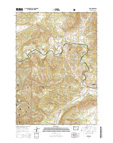
2014 Map of Wren
USGS Topo · Published 2014About this map
Marys River snakes through the center of this Benton County landscape, defining the valley where the communities of Wren, Harris, and Noon took root. The western portion of the sheet is dominated by the dense timberlands of the Siuslaw National Forest, rising toward landmarks like Pioneer Butte. This modern survey illustrates the residential expansion near the western edge of Philomath, where newer street names like Queen Anne Dr and Heritage Hills Dr contrast with the older rural infrastructure. Local history is anchored by three documented burial sites: Blodgett Cem, Wren Cem, and Pleasant Valley Cem. The map provides a detailed view of the drainage network feeding into the river, including Gellatly Cr, Woods Cr, and the Knight Reservoir, showing how the hydrology continues to shape both the protected forest lands and the developing agricultural and residential parcels of the valley.
Find a feature on this map
79 named features on this map. Tap any name to fly to it.
Don’t see what you’re looking for? This feature index may not catch every label — zoom into the map to look around manually.
Map Details
Editions of this 2014 Wren Map
This is the sole edition of this map. No revisions or reprints were ever made.
Other maps of this area

1911 · Inavale
USGS Topo · 1:31,680

1913 · Philomath
USGS Topo · 1:31,680

1914 · Soap Creek
USGS Topo · 1:31,680

1921 · Corvallis
USGS Topo · 1:62,500

1922 · Monroe
USGS Topo · 1:62,500

1939 · Marys Peak
USGS Topo · 1:62,500

1939 · Monroe
USGS Topo · 1:62,500

1942 · Marys Peak
USGS Topo · 1:62,500

1942 · Alsea
USGS Topo · 1:62,500

1942 · Monroe
USGS Topo · 1:62,500