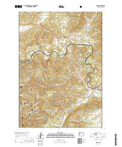
2020 Map of Wren
USGS Topo · Published 2020About this map
Wren and its surrounding Benton County hillsides appear here along the winding course of the Marys River, showing a landscape defined by small valley settlements and timbered ridges. The map documents the rural character of the region as of 2020, where the river meets tributaries like Woods Cr and Blakesley Cr. Local genealogy is anchored by established burial grounds, including Wren Cem north of the river and the Pleasant Valley Cem further south. To the west, the terrain rises toward the Siuslaw National Forest, marked by landmarks such as Pioneer Butte and the Mouse Mountain ridge. The settlement patterns follow older routes and rail corridors, connecting small locales like Harris and Noon with the larger footprint of Philomath. Hydrological features range from the North Fork Reservoir to named family ponds like Watkins Pond, reflecting the area's long-standing agricultural and water-management history.
Find a feature on this map
81 named features on this map. Tap any name to fly to it.
Don’t see what you’re looking for? This feature index may not catch every label — zoom into the map to look around manually.
Map Details
Editions of this 2020 Wren Map
This is the sole edition of this map. No revisions or reprints were ever made.
Other maps of this area

1911 · Inavale
USGS Topo · 1:31,680

1913 · Philomath
USGS Topo · 1:31,680

1914 · Soap Creek
USGS Topo · 1:31,680

1921 · Corvallis
USGS Topo · 1:62,500

1922 · Monroe
USGS Topo · 1:62,500

1939 · Marys Peak
USGS Topo · 1:62,500

1939 · Monroe
USGS Topo · 1:62,500

1942 · Marys Peak
USGS Topo · 1:62,500

1942 · Alsea
USGS Topo · 1:62,500

1942 · Monroe
USGS Topo · 1:62,500