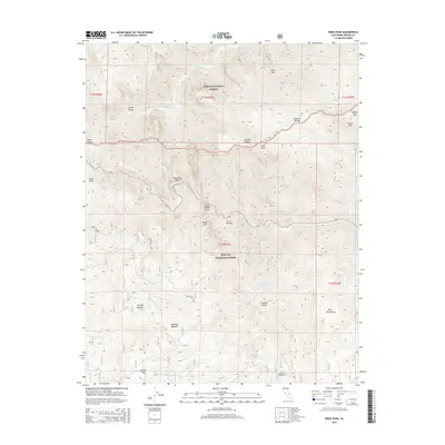
2015 Map of Wren Peak
USGS Topo · Published 2015About this map
The Sierra National Forest and Sequoia National Forest converge in this high-altitude landscape dominated by the Monarch Divide and the Middle Fork Kings River. This 2015 survey details the steep elevation drops from summits like Wren Peak and the prominent Grand Dike down into drainage systems fed by Silver Cr and Boulder Cr. The map shows a remote wilderness largely devoid of modern development, where topographic navigation relies on named landmarks such as Yucca Point and the sharp turn at Horseshoe Bend. High-country basins offer a series of distinct alpine meadows, including Tornado Meadow and Kennedy Meadow, which represent critical grazing or camping waypoints for those traversing the backcountry via Burton Pass. Forest Service infrastructure is minimal, represented by routes such as Forest Rte 13S05 and the proximity to Windy Cliffs.
Find a feature on this map
39 named features on this map. Tap any name to fly to it.
Don’t see what you’re looking for? This feature index may not catch every label — zoom into the map to look around manually.
Map Details
Editions of this 2015 Wren Peak Map
This is the sole edition of this map. No revisions or reprints were ever made.
Other maps of this area

1903 · Tehipite
USGS Topo · 1:125,000

1905 · Tehipite
USGS Topo · 1:125,000

1948 · Fresno
USGS Topo · 1:250,000

1952 · Tehipite Dome
USGS Topo · 1:62,500

1953 · Marion Peak
USGS Topo · 1:62,500

1955 · Fresno
USGS Topo · 1:250,000

1956 · Fresno
USGS Topo · 1:250,000

1956 · Giant Forest
USGS Topo · 1:62,500
1956 · Triple Divide Peak
USGS Topo · 1:62,500

1958 · Fresno
USGS Topo · 1:250,000