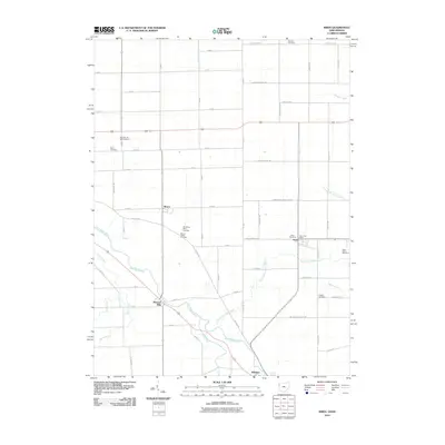
2010 Map of Wren
USGS Topo · Published 2010About this map
The Saint Marys River carves a diagonal path across this region of the Ohio-Indiana border, anchoring the settlements of Willshire and Pleasant Mills. The landscape is defined by an orderly grid of country roads, including State Line Rd, which marks the political boundary between the two states. The small village of Wren sits at a crossroads in the eastern half of the map, featuring the Wren Post Office and nearby Wren Cemetery. This area is particularly dense with sites of interest for genealogists, preserving several family and church burial grounds such as Old Mount Tabor Cemetery, McClure Cemetery, and Fletcher Cemetery. While the southern reach is dominated by the river and its tributaries like Twentyseven Mile Creek, the northern terrain includes the Decatur Hi-Way Airport, reflecting the integration of local aviation into this rural agricultural corridor.
Find a feature on this map
47 named features on this map. Tap any name to fly to it.
Don’t see what you’re looking for? This feature index may not catch every label — zoom into the map to look around manually.
Map Details
Editions of this 2010 Wren Map
This is the sole edition of this map. No revisions or reprints were ever made.
Other maps of this area

1911 · Berne
USGS Topo · 1:48,000

1914 · Celina
USGS Topo · 1:62,500

1914 · Van Wert
USGS Topo · 1:62,500

1944 · Van Wert
USGS Topo · 1:62,500

1944 · Celina
USGS Topo · 1:62,500

1953 · Muncie
USGS Topo · 1:250,000

1956 · Muncie
USGS Topo · 1:250,000
1960 · Convoy
USGS Topo · 1:24,000

1960 · Dixon
USGS Topo · 1:24,000
1960 · Rockford
USGS Topo · 1:24,000